Tuesday, September 29, 2009

Sunday - Day 2 - Legs D, E, & F

After a short night of sleep, I awoke at around 7:30 and was able to greet many of the riders that I hadn't seen the night before. Many were amazed that we rode in the dark and came in so late.

I brewed up a cup of tea using my very small alcohol burning ADVRider stove. Note the flames under the steel cup.

(Note to self: "Don't handle the cup after heating water this way!"

Heading up Route D, we came across this cool old water tank.


You can see that the road was paved. There are many sections like this throughout the Peninsula and it's a welcome relief from riding some of the gravel sections. Speaking of gravel, the gravel in the north and east portions of the ride tended to be on round gravel, while the gravel on the south and west sections tended to be crushed and much easier to ride on.

There were a lot of elevation gains in this section and lots of photo opportunities.


And here's Bart riding in "Scout position".


We leapfrogged with Ian from Touratech on his Triumph Tiger. Here he's doing his best Lewis & Clark pose and seems to like the ride.


Of course, what ride report from the Olympic Peninsula could leave out some flower or logging residue pictures?


And some more mountains


Riding out of the mountains, we found ourselves in Forks for a little fuel stop and a time to eat. Forks has gained recent notariety as the setting for a series of Twilight books about a Vampire named Edward and his teenage girlfriend, Bella. The town is clearly capitalizing on the trend. By the way, the Twilight sandwich was very good.

Here's David, Dan, and Ian.


Riding up the Clearwater Road, we came across these unusual mile marker signs. I wonder what they mean?


Unless you've ridden this road before, you wouldn't know that there is a correctional facility along this road and there is dense underbrush on both sides of the road that the escapees wouldn't even attempt to traverse. So they come out on the road and having 1/2 mile markers helps pinpoint them when pedestrians are reported to search parties as being on the road.

The rest of the day's ride took us up and over several saddles before dropping down into the Upper Clearwater Campground where we were to camp for the night. It was a very tranquil scene and it was good to arrive around 4pm and be able to set up camp for the night in the daylight.

Here's the bridge that spans the river. Those beams are laminated wood and note the rope swing that's available to use on those warm summer days.


One of the riders, Rick, camped with his Hennessy Hammock and it was impressive in how easy it was to set up and the sheer comfort.


The river was nearby.


Not a bad view out of my tent!


While we waited for riders to arrive, there was a little "shrimp on the barbie" to be prepared and eaten.


Walking around the campground, I came across this little mushroom.


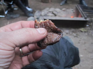
Then the hunters who were camped across the campground from us brought by some great treats (elk jerky, dried salmon, and pickled vegetables) which were enjoyed by all.


Eventually all of the riders showed up. Dinner and libations and some rousing stories were enjoyed around a blazing campfire before we retired to our tents and a good night's sleep. We still had one more day of riding and much of that 3rd day's route I had not previously ridden.

Saturday, Day 1 - Legs A, B, & C

In the northwest corner of Washington state, the Olympic Peninsula forms a large land mass that is bordered on 3 sides by water. The majority of the peninsula is now Olympic National Park (http://www.nps.gov/Olym/index.htm for more information) and is designated a wilderness area. There are no ways to drive or ride a motorcycle diagonal across the Park, but there is US101 which is a paved road that will take the rider or driver around the perimeter (about 400 miles). It's not a bad road at all, but for the dual sport motorcyclist, there's another way.

Years ago, much of the area was logged for it's primo timber and as a by product, a number of logging roads were carved into the terrain. The trick is how to connect those roads into a cohesive route. David McKay who runs www.griptwister.com has done the work and linked the various forest service, logging, and paved roads into a way to ride around the peninsula. He sells a self-guided GPS tour which notes not only the routes, but a number of scenic viewpoints, campgrounds, lodging, food, and fuel. In addition, once a year, he leads a tour using his routes and opens it to anyone who's purchased the tour. Back in 2007 I did the northern half of the tour with 4 friends, but couldn't get back to finish it in 2008. So when the tour came up for early September, 2009, I purposed to do it. It would be 3 days riding and 2 nights of camping. This report will document that ride and be accompanied by a few pictures. In the end, I found the last two sections to be so nice that a few weeks later, Bart (who I met on the tour) and I returned to re-ride those two sections plus a bonus section. That report will be part 2 of this blog.

The riders assembled in Hoodsport for a briefing. The riders formed natural groups to ride at the different speeds and interests.

Here's Paul from Touratech doing a little repair using my tools in my tool roll

Rick from Kalama is on the right (he rode with Bart & I on the 3rd day)

David (on the left) is instructing the riders


As for me when I'm dual sport riding, I'm more of a "flower sniffer" and like to take lots of pictures. Bart on his new BMW 1200GS hadn't ever been on a dual sport ride and Jim was on his Vstrom with street tires. Both indicated a desire to do the ride at the pace I was planning; and since I had done much of the first part, they agreed to ride with me. BTW, I really don't recommend riding this tour alone as much of the time, one is in very isolated areas.

So off we headed up into the hills. The first part of the route was paved, but soon the pavement ended and we began travelling on Forest Service (FS) roads. Here's an early vista of Lake Cushman.


Stepping to the edge of the lookout point, I spotted a little carnage down about 100 feet from the edge.


And it was not long until we encountered our first washout of the trip. There were a number of them ahead of them. Here's Bart traversing the washout.


There's about 4-5 feet of travelling width to work with. Just look where you want to go and take it easy.


There were lots more scenic vistas including these of Hood Canal.


And on every ride I try to take a mirror shot. Here's one from Day 1.


It wasn't too long before we reached our first obstacle and Bart's 1200 decided it was time for a nap.


And here's why one purchases Touratech engine guards.


We got Bart's BMW lifted up and back on the road. Going a little farther we encountered the following obstacle and decided to turn back.


Leaving the gravel and Leg A, we were on US101 for a short distance on our way to Quilcene for lunch at a favorite little restaurant (Logger's Landing). The views along the canal are not bad either.


I had the "light" hamburger (no bun).


At this point Jim decided to head for his home in Sequim via the paved roads while Bart and I elected to begin Leg B. It was good riding with Jim and I'm sure our paths will cross in the future.

As we were probably quite a bit behind the main group, we pretty much rode these two sections without stopping for many pictures. At the completion of B, we refueled in Sequim, and headed on west. Here's one of Bart on the pavement west of Port Angeles.


We stopped near Joyce to don some warmer clothes as the sun was setting and we still had a ways to go before reaching camp at Klahowya. We reached our turn-off from the pavement on WA112 onto the Twin River Road just as it got dark. That road was about 30 miles up over a mountain and the first part was extremely slick from moisture. I did a couple of "saves" when the bike started to slip out from under me. Bart also had a deer and its fawn run down the road in front of him in his headlights. The fawn particularly didn't want to leave the security of the headlights. We got turned around a couple of times up in that section of leg C as the track we were following wasn't displaying on my GPS.

Eventually we reached the pavement once again and found the campground and the group at 10pm. I had been riding since 6:30am. David and those who were still up greeted us and wanted to hear our tale which we obliged after we set up our tents.


There were also some brats & chips and soda to eat as we hadn't eaten since lunch at 3pm.

Going to bed around midnight, I found that I had a new bed partner (one of David's dogs adopted me).


Tomorrow was going to be a new day and perhaps we could make it into camp before dark. Time will tell.

Also, for more pictures, visit my picture hosting site at:

http://timmer.smugmug.com/Motorcycles/GripTwister-Olympic-Tour-2009/9661233_kNbvB/1/652080944_EgD2t

Stay tuned for Day 2 - Legs D, E, & F